Contents
Conventional signs and symbols used in maps:-
In a map or drawings or plans or in land surveying, the objects or an area is depicted by symbols not by names. As a civil engineer, you must know how to read the drawings, maps and plans. This post will be a key for you to read maps.
In this article, we are going to show you different types of symbols used in topographic land surveys, road maps, railway maps, surveying maps, building plans, Electrical and telephonic lines. You can use search option on table to find out the specific symbol of your entry.

Different types of Symbols used in Building plans :-
The below mentioned symbols are objects which we generally use in autocad drawings of building plans. Its the basic symbols which every civil engineer must remember.
| Object | Symbol |
|---|---|
| North Line is the direction along Earth's surface towards the geographic North Pole | 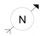 |
| Door | 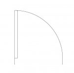 |
| Window | 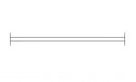 |
| Ventilator | 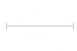 |
| Gate | 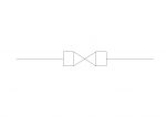 |
| Western Water Closet [WC] which is also called as Wester Commode | 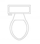 |
| Indian Water Closet [WC] | 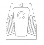 |
| Wall This symbol is usually used to represent outer wall which has a thickness of 9" |  |
| Partition wall Which is usually used in representing wall of partitioning. It has a thickness of 4" or 6" | 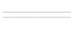 |
| Staircase | 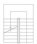 |
| Wire fencing The fencing around the building is done by wire. | |
| Pipe Fencing The fencing around the building is done by metallic pipes. | |
| Boundary Line |
Different types of Signs and Symbols used in Surveying maps :-
The below mentioned objects are Land surveying map symbols which we usually see in surveying maps (example plot map in a city).
| Objects | Symbols |
|---|---|
| Bench Mark which is used as reference point or called as permanent point this is usually marked with respect to known elevation (Mean Sea Level) | 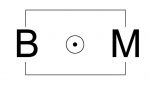 |
| Lake or Pond | 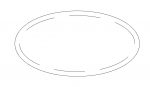 |
| River | 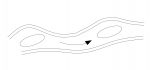 |
| Canal |  |
| Building (Pukka) |  |
| Huts |  |
| Temple |  |
| Masjid | 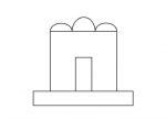 |
| Church | |
| Tree | 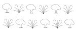 |
| Orchard | 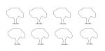 |
| Tube well | 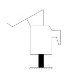 |
Different types of Symbols used in Road or Railway maps :-
These are the symbols which we use in depicting road survey or maps.
| Objects | Symbols |
|---|---|
| Metalled Road Roads which are made of bitumen of coal or cement concrete | 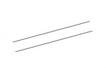 |
| Un-Metalled Road Roads which are laid using sand | 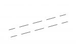 |
| Road Bridge | 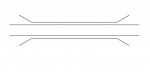 |
| Footpath | 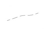 |
| Railway line (Single) | 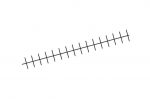 |
| Railway line (double) | 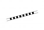 |
| Railway bridge | 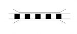 |
| Level Crossing | 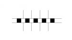 |
| Main stations or triangulation stations in chain survey | 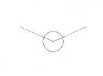 |
| Traverse stations or sub stations in chain surveying | 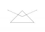 |
| Electric post | 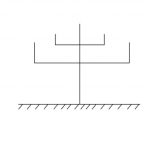 |
| Electric line | 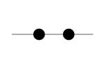 |
| Telegraphic Line | 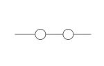 |
| Telegraphic post | 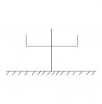 |
You can also download above mentioned objects in below attached CAD file in .dwg format.
Related Articles:
- Download 2 BHK, 3 BHK AUTOCAD drawing Samples [ Bedroom, Hall, Kitchen]
- Office And Apartments Plan Drawing Samples – AUTOCAD .dwg
For Instant updates Join our Whatsapp Broadcast. Save our Whatsapp contact +9700078271 as Civilread and Send us a message “JOIN”
Never Miss an update Click on “Allow US” and make us allow or Click on Red notification bell at bottom right and allow notifications.
Stay tuned!
Civil Read Wishes you ALL the BEST for your future.

thanks for making us to understand symbols
Hello sir, i have purchase in agriculture land , land FMB Mab front side draw – – – – – – this types of symbol . What is the meaning of symbol
its mean your land margin line
Very helpful site about Civil Related
Thanks for the clear awareness
Very useful symbols
what is the symbols for Barren land and Rocky land??
This symbols is useful for competitive exams
Greetings to you. Are surveying signs different from other signs and can they be mixed together ?